Vector Data: Unleashing Geographic Precision For Analysis And Visualization
Vector data represents geographic features using a coordinate system and a collection of geometric shapes such as points, lines, and polygons. It captures both the spatial location and attributes of these features, allowing precise representation, spatial analysis, and visualization.
Define geometry, topology, and attributes and explain their relationship with each other.
Understanding Geospatial Data: Geometry, Topology, and Attributes
In the realm of geospatial data, three fundamental concepts lay the foundation for accurately representing and analyzing the world around us: geometry, topology, and attributes.
Geometry: The Shape and Form
Geometry defines the physical characteristics of geographic features. It encompasses the shape, size, and precise location of points, lines, and polygons that represent natural or man-made entities on the earth’s surface. For instance, a lake may be depicted as a polygon, a road as a line, and a building as a point.
Topology: The Spatial Relationships
Topology describes how these geometric objects interact with each other. It captures the rules that govern their adjacency, connectivity, and containment. Topology ensures that, for example, countries share borders, rivers flow through watersheds, and buildings are connected to roads.
Attributes: The Descriptive Information
Attributes provide additional information that helps us understand and analyze geospatial data. They include both qualitative (e.g., land use type) and quantitative (e.g., population density) characteristics that describe the features. Attributes allow us to perform spatial analyses, such as identifying areas with high population density or finding the shortest path between two points.
The Interplay of Geometry, Topology, and Attributes
These three concepts intertwine to create a comprehensive representation of geographic information. Geometry provides the foundation, defining the shape and location of features. Topology establishes the spatial relationships between these features, ensuring that they interact in a logical and consistent manner. Attributes then enrich this framework with valuable information that enables us to extract meaningful insights from the data.
Understanding these fundamental concepts is essential for effectively utilizing geospatial data. They form the backbone of spatial analysis, enabling us to accurately represent, query, and analyze geographic information to solve complex problems, make informed decisions, and better understand our world.
The Interplay of Geometry, Topology, and Attributes in Geospatial Data: Digging Deeper into Coordinate Reference Systems
Understanding the fundamentals of geometry, topology, and attributes is crucial in the fascinating realm of geospatial data. These concepts lay the foundation for organizing and analyzing data, allowing us to make sense of the spatial relationships and characteristics of the world around us.
Coordinate Reference Systems: Anchoring Data to the Earth’s Surface
Imagine trying to navigate without a map or compass. The same principle applies to geospatial data: we need a way to anchor it to the real world. This is where the coordinate reference system (CRS) comes into play. A CRS is a set of rules that defines the location and orientation of a particular spatial data set on the Earth’s surface.
Spatial Reference Systems: Expanding the Framework
While a CRS provides a basic framework for referencing spatial data, it’s often not enough. The spatial reference system (SRS) takes it a step further by incorporating additional information such as the shape of the Earth (ellipsoid), the units of measurement, and the transformation parameters. SRSs provide a precise and consistent way to represent spatial data across different platforms and software applications.
CRS and SRS Working in Tandem
Think of the CRS as the blueprint for a construction project. It defines the overall location and dimensions of the building. The SRS, on the other hand, provides the detailed instructions for each step of construction. Together, the CRS and SRS create a comprehensive system for accurately and consistently locating and managing geospatial data.
Optimizing Your Search: SEO-Friendly Enhancements
- Use Keywords: Include relevant keywords throughout the blog post, such as “geospatial data,” “coordinate reference system,” and “spatial reference system.”
- Title Optimization: Craft a compelling title that accurately reflects the content and includes a relevant keyword: “Unlocking the Power of Geospatial Data: Understanding Coordinate Reference Systems and Spatial Reference Systems.”
- Subheading Tags: Use subheading tags (H2 and H3) to organize the content and highlight important sections, such as “The Interplay of Geometry, Topology, and Attributes” and “Coordinate Reference Systems: Anchoring Data to the Earth’s Surface.”
- Image Alt Text: Add descriptive alt text to any images or graphics to make them searchable and accessible to screen readers: “A diagram illustrating the relationship between geometry, topology, attributes, and coordinate reference systems.”
Metadata: The Key to Understanding Your Geospatial Data
In the realm of geospatial data, metadata plays a crucial role in unraveling the complexities of spatial information. Metadata, the behind-the-scenes information about your data, holds the key to understanding what it represents, how it was collected, and how to interpret it accurately.
Think of metadata as a treasure map guiding you through the intricacies of your geospatial data. It provides essential details, such as the date of collection, source, projection, and geographic extent. This information is akin to the legend on a map, explaining the symbols and colors used to represent different features on the ground.
With metadata, you can confidently pinpoint the geographical coordinates of specific locations, ensuring that your spatial analysis is grounded in reality. It allows you to determine whether your data is current and relevant to your research or project, preventing you from drawing erroneous conclusions based on outdated information.
Moreover, metadata facilitates seamless data sharing and collaboration among teams. By clearly documenting the parameters and specifications of your geospatial data, you empower others to understand and utilize it effectively. In this way, metadata fosters a greater understanding of the data landscape and enables informed decision-making.
The Importance of Coordinate Reference Systems (CRS) in Geospatial Precision
In the realm of geospatial data, precision is paramount for accurately representing and analyzing the Earth’s surface. A crucial element in achieving this precision is the Coordinate Reference System (CRS), a framework that defines the spatial relationships between geographic features.
Think of a CRS as a digital map of the Earth, but instead of using recognizable landmarks, it employs mathematical coordinates to pinpoint locations with precision. These coordinates are based on latitude (distance north or south of the equator) and longitude (distance east or west of the Prime Meridian).
The CRS serves as the foundation for georeferencing, the process of connecting geographic data to real-world locations. When a feature is georeferenced, its exact position on the Earth’s surface can be determined precisely using the defined CRS. This is essential for tasks such as mapping, navigation, resource management, and environmental analysis, ensuring that data is aligned and can be accurately compared and analyzed.
Without a well-defined CRS, geospatial data becomes ambiguous and difficult to interpret. Imagine trying to locate a house on a map without a grid system or knowing the scale. The CRS acts as the essential grid, providing the necessary framework to ensure that all geographic data is located and understood in the same manner.
By understanding the importance of a CRS, we empower ourselves to leverage geospatial data with confidence, knowing that the locations of features are accurately represented and can be analyzed precisely. It is the cornerstone of accurate spatial analysis, ensuring that our decisions and interpretations are grounded in reliable and well-defined geographic information.
Discuss the difference between a coordinate reference system and a spatial reference system.
Understanding the Nuances: Coordinate Reference Systems vs. Spatial Reference Systems
In the captivating world of geospatial data, precision is paramount. Enter coordinate reference systems (CRS) and spatial reference systems (SRS). While their names may sound similar, understanding their subtle differences is crucial for accurately representing geographic information.
Imagine a vast map of the earth’s surface, with each location precisely plotted using a set of numbers called coordinates. A CRS defines the rules that determine how these coordinates relate to the earth’s shape, size, and orientation. It’s like a standardized language for describing locations, ensuring that everyone can understand where features are situated.
An SRS, on the other hand, takes the CRS a step further by adding metadata that describes the CRS and provides additional information about the data. This metadata includes details like the type of projection used, the units of measurement, and the accuracy of the data. It’s the passport that allows data from different sources to seamlessly communicate and be compared.
To illustrate the distinction, imagine two groups of explorers using different maps of a remote island. One group has a CRS-based map that shows the island’s outline and major landmarks. The other group has an SRS-based map that includes not only the same information but also the scale of the map, the elevation data, and the date the map was created. The SRS-based map provides a richer understanding of the island’s geography, enabling the explorers to make more informed decisions about their journey.
In summary, a CRS provides the essential framework for locating features on the earth’s surface, while an SRS enhances that framework with additional metadata, making geospatial data more reliable, comparable, and accessible. Understanding this difference is a cornerstone for unlocking the full potential of spatial analysis and unraveling the mysteries of our geographic world.
Connecting Data to the Real World: Georeferencing
In the realm of geospatial data, understanding its connection to the real world is crucial. This is where georeferencing comes into play.
Georeferencing is the process of assigning real-world coordinates to digital data. It’s like giving each piece of data a unique address on the planet. This enables computers to precisely locate and display geographic features in their correct positions.
Think of it as a digital mapping system. Georeferencing ensures that every house, road, and lake in your digital map corresponds to its actual location on Earth. Without it, data would be floating in a virtual void, making it impossible to analyze or use effectively.
Process and Importance
Georeferencing is a multi-step process. First, a set of known coordinates (called control points) is established on the map and in the real world. Then, the data points are adjusted based on their relationship to these control points.
Accurate georeferencing is essential for spatial analysis and decision-making. Imagine planning a new road or park. Without georeferenced data, it would be impossible to determine the best location based on factors like elevation, land use, and infrastructure.
Benefits of Georeferencing
- Precise Visualization: Georeferenced data can be overlaid on maps and satellite imagery, allowing for a clear representation of its actual location.
- Spatial Analysis: By assigning coordinates, data can be analyzed in relation to its spatial context, enabling the identification of patterns and relationships.
- Decision-Making: Georeferencing provides a solid foundation for informed decision-making by providing accurate location information for planning and development.
- Data Integration: Different datasets can be integrated and analyzed together when they are georeferenced to a common coordinate system.
Georeferencing is the key that unlocks the true power of geographic data. It connects digital information to the physical world, enabling us to visualize, analyze, and make decisions based on a comprehensive understanding of our surroundings. By assigning coordinates to our data, we empower ourselves to better interact with and navigate the complex world we live in.
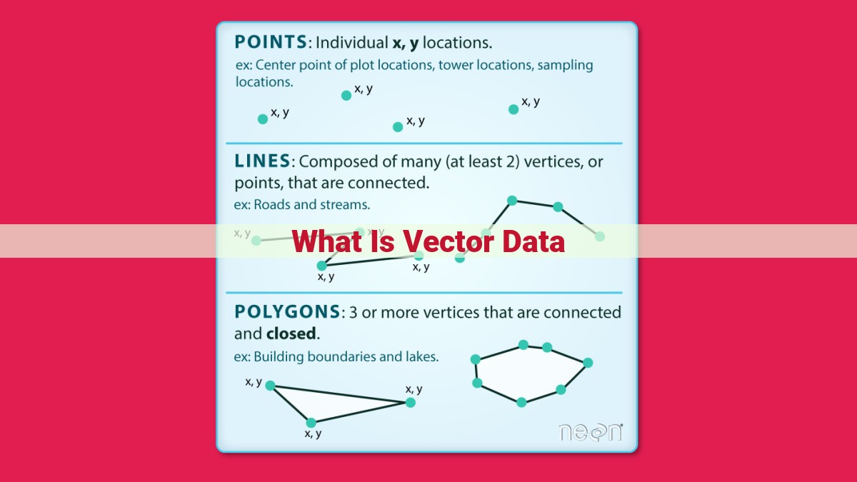
Describe the characteristics of vector data, including points, lines, and polygons, and how they are used to represent geographic features.
Understanding Vector Data: The Building Blocks of Spatial Representation
As we navigate the world of spatial data, it’s essential to understand the different ways in which geographic features can be represented. Vector data emerges as a powerful tool for capturing and visualizing the real world in a digital format.
Vector data is a collection of points, lines, and polygons that describe the geometry of geographic features. Points represent discrete locations, lines connect points to create linear features such as roads or rivers, and polygons outline areas representing buildings, parks, or lakes.
The beauty of vector data lies in its ability to capture not only the shape and location of features but also attribute information. Attributes are data associated with each feature, such as its name, type, description, or population. By linking geometry to attributes, vector data creates a rich tapestry of information that can be analyzed to derive insights about the real world.
For example, a vector dataset of roads could include attributes such as road type, speed limit, and traffic volume. This data can be used for route planning, traffic analysis, or optimizing emergency response times. Similarly, a vector dataset of buildings could contain attributes such as building height, construction materials, and occupancy information. This data can be leveraged for land use planning, urban planning, and property management.
The power of vector data lies in its ability to accurately represent the real world in a digital format. It allows us to capture not only the physical characteristics of geographic features but also the rich tapestry of information associated with them. By leveraging vector data, we can unlock the full potential of spatial analysis and gain valuable insights into the world around us.
Spatial Analysis: Unlocking the Power of Geometry, Topology, and Attributes
In the realm of geospatial data, understanding the intricate relationship between geometry, topology, attributes, and vector data is paramount for conducting meaningful spatial analysis.
Geometry defines the shape and location of features on the earth’s surface. It encompasses points, lines, and polygons, allowing us to represent geographic features such as buildings, roads, and rivers.
Topology describes the spatial relationships between features, capturing how they connect and interact. It establishes rules for connectivity, such as the adjacency and containment of features.
Attributes provide additional information about features, such as their name, population, or elevation. By linking attributes to geometry and topology, we gain a richer understanding of the spatial distribution of these characteristics.
In the context of vector data, geometry, topology, and attributes work in harmony to create a comprehensive representation of geographic phenomena. Vector data allows us to capture not only the location of features but also their spatial relationships and associated information.
Spatial analysis leverages these intertwined concepts to extract meaningful insights from geospatial data. By analyzing the geometry of features, we can determine their distance, area, or shape. Topology helps us identify patterns and connections, such as which roads intersect or which neighborhoods are adjacent. Attributes enable us to explore relationships between spatial patterns and other variables, like population density or land use.
Together, geometry, topology, and attributes provide a powerful foundation for spatial analysis, empowering us to unravel the complexities of the physical world and make informed decisions based on data-driven insights.
