Unlocking Seismograms: A Comprehensive Guide To Earthquake Analysis
To read a seismograph, start by identifying the different seismic waves (P-waves, S-waves, and surface waves) and their arrival times. Use these times to determine the distance to the earthquake’s epicenter. The seismogram’s amplitude provides information about the earthquake’s magnitude, while its frequency and duration reveal details about the earthquake’s characteristics. By analyzing these parameters, seismologists can estimate the earthquake’s location, magnitude, and potential impact.
Earthquakes are powerful natural phenomena that can have devastating consequences. To understand these events and mitigate their impact, scientists rely on seismographs, indispensable instruments that provide crucial insights into the nature of earthquakes.
Why Seismographs Are So Important
Seismographs are vital for studying earthquakes because they detect and record seismic waves generated by these events. These waves travel through the Earth’s crust, carrying information about the earthquake’s magnitude, location, and depth. By analyzing these waves, scientists can gain a deeper understanding of earthquake processes and their potential impacts on human populations.
Understanding earthquakes is essential for risk assessment and preparedness. Seismographs help scientists identify areas at higher risk of earthquakes, allowing communities to take necessary precautions, such as strengthening buildings and developing emergency response plans.
Understanding Seismograph Fundamentals
Seismographs: Guardians of the Earth’s Seismic Secrets
Seismographs are indispensable tools in the world of seismology, the study of earthquakes and other seismic activities. These ingenious instruments act as the eyes and ears of scientists, allowing them to detect and analyze the Earth’s subterranean tremors.
Seismic Waves: The Telltale Signs of Earth’s Movement
When an earthquake occurs, it sends out seismic waves that ripple through the Earth’s layers. These waves come in three primary types:
- P-waves (Primary waves): The fastest and first-arriving waves, they travel through both solid and liquid layers of the Earth.
- S-waves (Secondary waves): Shear waves that follow P-waves and can only travel through solid rock.
- Surface waves: Complex waves that travel along the Earth’s surface, often causing significant ground shaking.
Each type of seismic wave has its unique characteristics, which seismographs can detect and measure. By analyzing these recorded vibrations, scientists can decipher the nature and location of earthquakes.
Interpreting a Seismogram: Unraveling the Earthquake Story
Components of a Seismogram
A seismogram is a graphical representation of the ground motion recorded by a seismograph. It consists of three main components:
- Time axis: The horizontal axis of the seismogram represents time.
- Amplitude axis: The vertical axis represents the amplitude or strength of the ground motion.
- Trace: The wiggly line on the seismogram indicates the recorded ground motion.
Identifying Seismic Wave Arrival Times
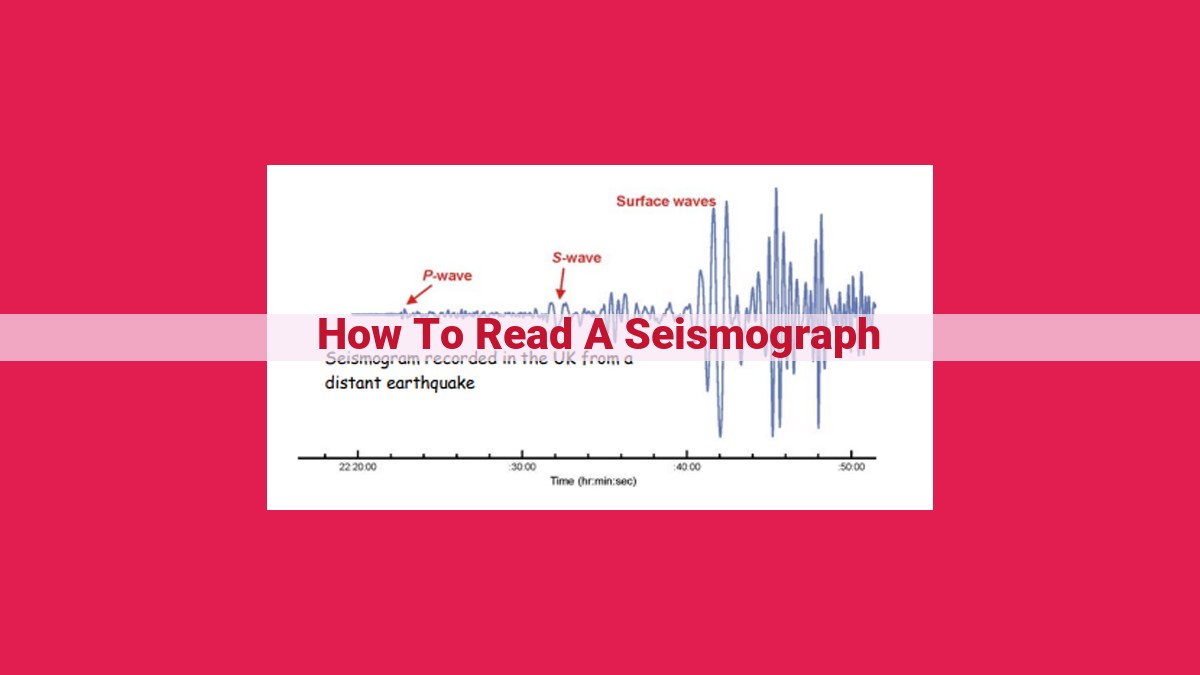
Different types of seismic waves travel at different speeds through the Earth’s layers. P-waves, or primary waves, are the fastest and arrive first. S-waves, or secondary waves, are slower and arrive later. Surface waves, or L-waves, are the slowest and have the largest amplitudes.
On a seismogram, the arrival time of each wave is marked by a sudden change in the trace. By measuring the time difference between the arrival times of the P-waves and S-waves, seismologists can estimate the distance to the earthquake epicenter.
Determining Epicenter Distance
The distance to the earthquake epicenter can be determined using a technique called triangulation. By combining the arrival times of seismic waves recorded at multiple seismograph stations, seismologists can calculate the location of the epicenter.
This triangulation process involves:
- Measuring the time difference between P-wave and S-wave arrivals.
- Estimating the distance to the epicenter based on the time difference.
- Plotting the distances on a map to form circles representing potential epicenter locations.
- Finding the common point of intersection of the circles, which indicates the epicenter.
Quantifying Earthquake Characteristics
Earthquakes, with their unpredictable nature and devastating potential, have long been a subject of scientific inquiry. At the heart of this exploration lies a remarkable instrument called a seismograph, a device capable of detecting and recording seismic waves generated by earthquakes. Through the analysis of these waves, scientists have developed ingenious methods to quantify earthquake characteristics, revealing insights into the magnitude, intensity, and location of these powerful events.
Earthquake Magnitude: A Measure of Energy Release
The magnitude of an earthquake is a measure of the energy released during the event. It is calculated using the amplitude of seismic waves recorded by seismographs. The larger the amplitude, the greater the energy released and the stronger the earthquake. The most common scale used to measure magnitude is the Richter scale, which assigns a numerical value ranging from 1 to 10. Each whole number increment represents a tenfold increase in energy release.
Intensity: Assessing Ground Shaking
While magnitude measures the overall energy released by an earthquake, intensity measures the intensity of ground shaking at a specific location. It is typically expressed on a Modified Mercalli Intensity (MMI) scale, which ranges from I (not felt) to XII (catastrophic damage). The MMI scale considers factors such as perceived shaking, building damage, and environmental effects. By combining the intensity readings from multiple seismograph stations, scientists can create intensity maps that illustrate the spatial distribution of ground shaking.
Determining Epicenter and Focus: Pinpointing the Earthquake’s Location
Seismograph recordings enable scientists to pinpoint the epicenter of an earthquake, the point on the Earth’s surface directly above the hypocenter, the point where the earthquake originates. By analyzing the time difference between the arrival of seismic waves at different seismograph stations, scientists can use a method known as triangulation to calculate the distance to the earthquake’s epicenter. The depth of the hypocenter, known as the focal depth, can also be estimated using additional seismic data. This information is crucial for understanding the location and potential impact of an earthquake, aiding in disaster response and earthquake hazard assessment.
Expanding Your Earthquake Vocabulary: Key Concepts
When discussing earthquakes, it’s essential to understand related concepts beyond the basics. Let’s explore some key terms that will enrich your earthquake vocabulary.
Seismic Stations: The Earthquake Watchtowers
Seismic stations are the eyes and ears of earthquake monitoring. These specialized facilities house sensitive seismographs that continuously record ground motion. Their wide distribution allows for the triangulation of earthquake locations, providing valuable data for early warning systems and research.
Seismic Waves: Nature’s Earthquake Messengers
Seismic waves are the pulsating signals that carry earthquake energy through the Earth. They come in three main types:
- P-waves (primary waves): The fastest and first to arrive, these longitudinal waves travel through the Earth’s interior, vibrating particles in the same direction as their propagation.
- S-waves (secondary waves): These slower transverse waves travel through the Earth’s interior, vibrating particles perpendicular to their propagation direction.
- Surface waves (Love waves and Rayleigh waves): These waves travel along the Earth’s surface, causing ground motion that can range from gentle swaying to violent shaking.
Seismic Epicenter and Focus: Pinpointing Earthquake Origins
The epicenter is the point on the Earth’s surface directly above the earthquake’s focus, where the rupture begins. The focus, also known as the hypocenter, is the point within the Earth where the rupture occurs. Understanding these locations helps scientists determine the depth of an earthquake and the potential for ground shaking in different areas.
Practical Applications of Seismographs: Unveiling the Earth’s Secrets
Beyond their crucial role in detecting earthquakes, seismographs offer a myriad of practical applications that delve into the depths of our planet’s mysteries.
Real-Time Earthquake Monitoring
Seismographs stand as the sentinels of our planet, providing real-time monitoring of seismic activity. They act as early warning systems, giving valuable time for earthquake preparedness and potentially saving lives. By detecting tremors that often precede major quakes, seismographs empower us to take crucial actions, such as evacuating buildings or seeking shelter.
Precise Earthquake Magnitude and Location
Seismographs not only detect earthquakes but also provide accurate estimates of their magnitude and location. Through analyzing the patterns and amplitudes of seismic waves, scientists can pinpoint the epicenter (surface point directly above the quake) and determine the strength of the quake. This information is vital for earthquake response, enabling authorities to quickly assess the impact and allocate resources accordingly.
Probing the Earth’s Interior
Seismographs play a pivotal role in unraveling the secrets of the Earth’s interior. By studying the seismic waves that travel through the Earth’s layers, scientists can map out the planet’s internal structure, including the thickness and composition of its crust, mantle, and core. This knowledge deepens our understanding of plate tectonics, volcanic activity, and other geological phenomena.
