Turbulent Skies: Understanding Cloud Types With Extreme Turbulence
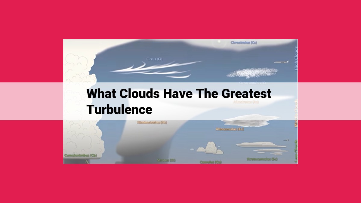
Clouds with the greatest turbulence are convective clouds, characterized by strong updrafts within their towering structures. Thunderstorms, the most severe of convective clouds, produce intense updrafts and downdrafts that cause extreme turbulence. Cumulonimbus clouds, the parent clouds of thunderstorms, also exhibit significant turbulence due to their towering height and updrafts. Mammatus clouds, with their pouch-like formations, and pileus clouds, which appear as caps atop thunderclouds, are also associated with turbulence. Other cloud types, such as cirrus, lenticular, stratus, and cumulus, generally have lower levels of turbulence.
Cloud Types: A Guide to the Sky’s Ever-Changing Canvas
Clouds, the ethereal dancers in the sky’s vast expanse, are not mere wispy formations. Each type tells a unique tale, revealing the hidden forces that shape our celestial tapestry. Join us on an enchanting journey as we unravel the secrets of cloud types and their fascinating characteristics.
Convective Clouds: The Turbulence Kings
Picture the sky adorned with towering giants, their puffy crowns reaching heavensward. These are convective clouds, the architects of turbulence. Their upwardly surging air currents, like miniature tornadoes, create intense updrafts that can make your plane dance and your stomach do somersaults.
Thunderstorms: Nature’s Symphony of Fury
Among convective clouds, thunderstorms stand as the most formidable force. Their towering cumulonimbus clouds, the mothers of lightning, unleash nature’s symphony of fury. Violent updrafts and downdrafts collide within these celestial giants, generating the extreme turbulence that makes pilots wary and passengers nervous.
Cumulonimbus Clouds: The Thunderstorm’s Mighty Parent
Cumulonimbus clouds, the parent clouds of thunderstorms, are towering behemoths that can reach heights of several miles. Their anvil-shaped tops, a telltale sign of their upward thrust, are a warning to mariners and aviators alike.
Mammatus Clouds: The Pouches of the Sky
At the base of cumulonimbus clouds, like celestial pouches, hang mammatus clouds. Their bulbous, undulating shape gives them an eerie yet beautiful appearance. They form as updrafts push against stable air layers above, creating these otherworldly bubbles.
Pileus Clouds: Caps Atop the Thunderclouds
Perched atop thunderclouds, like tiny hats, rest pileus clouds. Thin and wispy, they form due to the strong updrafts of the cumulonimbus below. They serve as a warning, indicating the presence of turbulent conditions within the cloud behemoth beneath.
Other Cloud Types and Turbulence
While convective clouds reign supreme in the world of turbulence, other cloud types also deserve mention. Cirrus clouds, the wispy, feathery strands, pose little threat. Lenticular clouds, lens-shaped formations, can sometimes generate turbulence depending on wind conditions. Stratus clouds, the flat, featureless sheets, generally bring calm skies. And cumulus clouds, the puffy cotton balls, may occasionally cause bumps due to their updrafts.
Convective Clouds: The Kings of Turbulence
- Definition and characteristics of convective clouds.
- Formation and updrafts that cause intense turbulence.
Convective Clouds: The Kings of Turbulence
In the realm of clouds, there are some that reign supreme in their ability to cause intense turbulence, and these are the mighty convective clouds. These clouds are characterized by their towering height, dramatic updrafts, and the potential for severe turbulence.
Convective clouds form when warm, moist air rises rapidly, creating towering columns of moisture. As the air rises, it cools and condenses, forming clouds. The updrafts within these clouds can be extremely powerful, sometimes reaching speeds of up to 100 miles per hour. These updrafts are what cause the intense turbulence that pilots and passengers dread.
When an aircraft encounters a convective cloud, it can be subjected to violent shaking, sudden drops, and changes in direction. The turbulence can be so severe that it can damage aircraft and cause injuries to passengers. For this reason, pilots are trained to avoid convective clouds whenever possible.
Formation and Updrafts
Convective clouds typically begin as small, puffy clouds called cumulus clouds. As the updrafts within these clouds strengthen, they can grow into towering giants known as cumulonimbus clouds. Cumulonimbus clouds are associated with thunderstorms, heavy rainfall, and lightning.
The updrafts within convective clouds are driven by the release of latent heat as water vapor condenses into liquid water. This process releases energy, which causes the air to expand and rise. The updrafts can be further strengthened by the presence of wind shear, which is a difference in wind speed and direction at different altitudes.
Pilot’s Perspective
For pilots, convective clouds are a major hazard. Turbulence can make it difficult to control an aircraft, and sudden changes in altitude can cause the aircraft to stall or lose control. Pilots are trained to use weather radar and other tools to detect convective clouds and avoid them. However, sometimes it is impossible to avoid these clouds, and pilots must be prepared to deal with the turbulence they encounter.
Passenger Comfort
For passengers, convective clouds can be a source of discomfort and even fear. Turbulence can cause nausea, dizziness, and other unpleasant symptoms. In extreme cases, turbulence can even cause injuries. Passengers should be aware of the potential for turbulence when flying and should take precautions to minimize their discomfort, such as wearing a seatbelt and avoiding caffeine and alcohol.
Thunderstorms: Nature’s Fury
When the skies turn a menacing shade of gray and the air crackles with electricity, you know you’re in the presence of a thunderstorm, the most formidable of convective clouds. These behemoths of the sky wield immense power, unleashing a symphony of thunderous roars and blinding lightning bolts.
Thunderstorms are born from intense updrafts that rush heated air skyward, creating a towering anvil of a cloud. Within this tempestuous realm, updrafts and downdrafts collide like celestial giants, churning the air into a swirling maelstrom. These violent updrafts and downdrafts generate extreme turbulence, testing the mettle of even the most seasoned pilots.
The downdrafts, particularly, are a force to be reckoned with. These icy blasts of air can plunge thousands of feet in mere minutes, creating downbursts that can wreak havoc on the ground. They’re like invisible hurricanes, leveling vegetation and structures with their fury.
But thunderstorms aren’t all about destruction. They also play a vital role in nature’s balancing act. Their lightning discharges release energy that helps purify the air, while their copious rainfall replenishes water sources and nourishes the earth.
So, as you witness the raw power of a thunderstorm from afar, remember both its destabilizing and purifying influence. It’s a force that can both awe and inspire, a testament to the untamed beauty and power of our planet.
Cumulonimbus Clouds: The Parent of Thunderstorms
- Towering height and associated features of cumulonimbus clouds.
- Role as the parent cloud of thunderstorms.
Cumulonimbus Clouds: The Majestic Parents of Thunderstorms
Cumulonimbus clouds, towering giants of the skies, hold a special place in the realm of clouds. Known as the parent clouds of thunderstorms, they stand as symbols of nature’s raw power and awe-inspiring beauty.
Towering Heights and Formidable Features
Cumulonimbus clouds are distinguished by their immense height, often reaching above 20,000 feet. Their imposing presence can be seen from miles away, as they stretch towards the heavens like celestial mountains. The towering anvil-shaped top, a signature feature, resembles a blacksmith’s anvil used to shape molten metal.
The Genesis of Thunderstorms
These mighty clouds are the primary source of thunderstorms, those dramatic displays of nature’s fury. Within their towering depths, intense updrafts and downdrafts collide, creating the conditions for lightning, thunder, and torrential rain. The towering anvil-shaped tops act as the anvil, shaping the updrafts and contributing to the storm’s intensity.
The Role of Cumulonimbus Clouds
Cumulonimbus clouds are more than just harbingers of thunderstorms. They play a crucial role in the atmosphere’s delicate balance. Their towering height allows them to transport moisture from the Earth’s surface to the upper atmosphere, contributing to the global water cycle. Additionally, they cleanse the air of pollutants and create new cloud droplets through their intricate internal processes.
Cumulonimbus clouds are extraordinary formations that command respect and awe. Their towering presence, imposing features, and role as the parent clouds of thunderstorms make them a captivating subject for meteorologists and sky enthusiasts alike. Understanding these majestic giants is essential for aviation safety, as they pose significant risks to aircraft.
Mammatus Clouds: The Enchanting Pouches in the Sky
As you gaze skyward on a serene day, you may stumble upon an ethereal sight: mammatus clouds. These mesmerizing formations resemble pouches or udders hanging from the underside of a larger cloud mass.
Unveiling the Nature of Mammatus
Mammatus clouds are a 独特的 type of cloud that forms at the base of towering cumulonimbus clouds. They are characterized by their distinct pouch-like or bubble-shaped appearance. These wispy pockets of air are often creamy white in color and have a deflated look.
The Formation of These Aerial Wonders
Mammatus clouds owe their existence to the updrafts and downdrafts occurring within cumulonimbus clouds. When moist air rises in an updraft, it cools and condenses, forming the bulging pouches of mammatus.
A Rare and Transient Spectacle
Mammatus clouds are 較少見 and can only exist for short periods. They often dissipate within a matter of minutes, giving way to a more uniform cloud cover. But their fleeting nature makes them all the more enchanting.
Implications for Aviation
Understanding mammatus clouds is crucial for aviation safety. These clouds can indicate severe weather conditions, such as tornadoes, hail, and thunderstorms. Pilots closely monitor their presence to avoid potentially hazardous situations.
Embrace the Magic of Mammatus
The next time you see mammatus clouds, take a moment to appreciate their beauty. They are a reminder of the dynamic and ever-changing nature of our atmosphere. These celestial pouches are a precious gift, offering a glimpse into the secrets of the sky above.
Pileus Clouds: The Feather Caps Atop Thunderclouds
In the realm of towering cumulonimbus clouds, where thunder roars and lightning strikes, there dwells a peculiar cloud formation that often adorns their summits like a regal headdress. These are the pileus clouds, named after the Latin word for “cap.”
Pileus clouds are thin, flat wisps of cloud that resemble a feathery cap or a small, flat disc. They form above the anvil top of the cumulonimbus cloud, seemingly crowning the mighty thundercloud. These caps are often smooth and uniform in appearance, creating a striking contrast against the roiling turbulence below.
The presence of pileus clouds signifies intense updrafts within the towering cumulonimbus cloud. As the powerful updrafts surge upward, they carry with them moisture and tiny ice crystals. These ice crystals cool the air, creating a thin layer of stable air that caps the top of the cloud. This stable layer acts as a lid, preventing the cloud from further vertical growth.
While pileus clouds are generally associated with calm and stable conditions, they can occasionally produce light turbulence due to the shearing between the strong updrafts below and the stable air above. However, this turbulence is typically mild compared to the severe turbulence often encountered within the convective core of the cumulonimbus cloud.
Pileus clouds serve as a valuable indicator for pilots, providing insights into the intensity and structure of the cumulonimbus cloud below. By observing the presence and behavior of pileus clouds, pilots can anticipate areas of turbulence and make informed decisions to avoid hazardous weather conditions.
Other Cloud Types and Their Turbulence Levels
As we venture into the realm of clouds, we encounter a diverse tapestry of formations, each with its unique character and turbulence profile. While convective clouds reign supreme in the turbulence department, other cloud types also deserve attention for their varying levels of bumpiness.
- Cirrus Clouds: Wispy and Tranquil
Soaring high in the sky, cirrus clouds present a thin, wispy appearance. Composed primarily of ice crystals, these clouds pose minimal turbulence, making them a relatively serene sight for pilots. A related cloud formation, lenticular clouds, can sometimes arise near mountain ranges, exhibiting a lens-like shape. While generally calm, they may occasionally generate turbulence due to their interactions with nearby terrain.
- Stratus Clouds: Flat and Placid
Stratus clouds, with their flat, layered appearance, often blanket the sky like a uniform sheet. These clouds are typically devoid of significant turbulence, providing a smooth and stable flying experience. Their presence often indicates stable atmospheric conditions.
- Cumulus Clouds: Puffy and Occasionally Bumpy
Cumulus clouds, characterized by their towering, puffy shapes, can occasionally cause turbulence in their updrafts. As warm air rises within these clouds, it creates updrafts that can jostle aircraft. However, the turbulence associated with cumulus clouds is generally mild and manageable for most pilots.
In summary, while convective clouds pose the greatest turbulence hazards, other cloud types exhibit varying levels of bumpiness. Cirrus clouds and stratus clouds offer a relatively smooth flight, while lenticular clouds and cumulus clouds may present occasional turbulence. Understanding the characteristics of these cloud types and their potential for turbulence is crucial for pilots to ensure a safe and comfortable flight experience.
Cirrus Clouds: Wispy and Serene in the Heavenly Canvas
As we gaze upward, our eyes are often drawn to the celestial tapestry adorned with clouds, each type possessing unique characteristics and a story to tell. Among these cloud formations, cirrus clouds stand out as wispy and serene, with their gentle presence and minimal disruption to the aviation journey.
Cirrus clouds, also known as “mare’s tails,” are thin, feathery clouds that often appear as streaks or tufts in the sky. Composed primarily of ice crystals, they float high above the earth, typically between 5,000 and 12,000 meters. Their delicate nature and high altitude make them harmless to aircraft, offering a smooth and tranquil flight experience.
Related Concept: Lenticular Clouds
Lenticular clouds are a fascinating variation of cirrus clouds that sometimes resemble lenses or saucers. They form when strong winds encounter mountain peaks or other terrain features, creating a distinctive shape. While lenticular clouds generally have minimal turbulence, they can occasionally generate moderate bumpiness when their winds align with the direction of the aircraft’s flight path.
Lenticular Clouds: The Elusive and Enigmatic
Lenticular clouds, with their mesmerizing lens-shaped forms, often grace the skies with their ethereal presence. These captivating formations are a testament to the intricate interplay between wind and atmosphere.
While lenticular clouds typically appear serene, they can sometimes conceal a turbulent secret. When winds encounter an obstacle, such as a mountain or a ridge, they can be forced upward. As the air rises, it cools and condenses, forming these enigmatic clouds.
Lenticular clouds often parallel the shape of the obstacle that caused their formation. They can range in size from small, delicate lenses to massive, awe-inspiring spectacles. Their close resemblance to flying saucers has even sparked speculation of extraterrestrial origins.
The turbulence associated with lenticular clouds depends on several factors. Strong winds and a stable atmosphere can create smooth updrafts, resulting in minimal turbulence. However, when the wind speed increases and the atmosphere becomes unstable, severe turbulence can occur. Pilots must be aware of this potential hazard and exercise caution when encountering these enigmatic clouds.
As the sun sets, lenticular clouds may transform into even more extraordinary sights. Backlit by the golden rays, they glow with an almost ethereal radiance. This mesmerizing spectacle is a testament to the beauty and wonder that can be found in the sky above.
Stratus Clouds: Flat, Layered, and (Usually) Calm
Among the vast tapestry of clouds in the sky, stratus clouds stand out for their flat, layered appearance. These ethereal blankets stretch across the heavens, adding a touch of uniformity to the often chaotic celestial canvas.
As their name suggests, stratus clouds are characterized by their flat, sheet-like shape. They resemble a uniform layer of gray that covers the sky, often resembling a dull, overcast day. Unlike cumulus clouds with their puffy, cotton-like appearance, stratus clouds are smooth and featureless, devoid of any discernible shape or structure.
The calm demeanor of stratus clouds is perhaps their most defining feature. Unlike their more turbulent counterparts, stratus clouds rarely produce turbulence. Their gentle, steady updrafts and lack of significant vertical development make them a welcome sight for pilots and passengers alike.
In fact, the absence of turbulence in stratus clouds is an indicator of stable atmospheric conditions. The stable air mass within these clouds prevents the formation of strong updrafts and downdrafts, resulting in the calm and serene nature that stratus clouds are known for.
However, it’s important to note that even within the realm of stratus clouds, there can be occasional variations. While most stratus clouds are associated with low levels of turbulence, occasional patches of moderate turbulence may be encountered within these clouds. These localized areas of turbulence are often associated with small-scale wind shear or temperature inversions, but they rarely pose a significant threat to aircraft.
In conclusion, stratus clouds are a common sight in the sky, characterized by their flat, layered appearance and generally calm nature. Their uniform, featureless structure and absence of significant turbulence make them a welcome presence for those seeking smooth and tranquil skies. While occasional patches of turbulence may occur within stratus clouds, these are rare and generally not a cause for concern.
Cumulus Clouds: Puffy and Occasionally Bumpy
Among the various cloud formations that adorn the sky, cumulus clouds stand out as puffy and cotton-like, resembling celestial cotton balls. These clouds are typically associated with fair weather and calm skies. However, even these seemingly harmless clouds can harbor secret pockets of turbulence.
Updrafts and Occasional Bumps
Cumulus clouds are formed when warm, moist air rises from the ground and condenses, creating towering mounds in the sky. Within these clouds, updrafts, or columns of rising air, carry water vapor upwards, leading to the growth of the cloud. Occasionally, these updrafts can become strong and localized, causing brief and mild turbulence. Passengers may experience a gentle bounce or jolt as the aircraft passes through these areas of turbulence within the cumulus cloud.
Calm Skies in General
Despite the potential for occasional bumps, cumulus clouds generally do not pose a significant threat to aviation. They are relatively thin and small compared to their more turbulent counterparts, such as thunderstorms. Pilots can often navigate around them or fly through them without encountering significant turbulence.
Tips for Navigating Cumulus Clouds
For pilots, understanding the characteristics of cumulus clouds is crucial for maintaining a smooth and safe flight. When encountering cumulus clouds, pilots may adjust their altitude to avoid areas of potential turbulence. Additionally, they can use weather radar to identify and avoid more significant cloud formations that may harbor more severe turbulence.
Cumulus clouds, while generally associated with fair weather, can occasionally produce brief and localized turbulence. Pilots must be aware of the potential for turbulence within these clouds and use their knowledge and experience to navigate them safely. Understanding cloud formations is an essential component of aviation safety, allowing pilots to make informed decisions and ensure a comfortable and safe journey for their passengers.
