Astrolabe: Empowering European Exploration Through Celestial Navigation
The astrolabe, a pivotal tool in the Age of Exploration, empowered European explorers by enabling celestial navigation. Using the astrolabe, explorers could accurately determine their latitude and time of day, allowing them to chart their courses across vast oceans. Additionally, the astrolabe provided insights into weather patterns, aiding in voyage planning. By harnessing the stars, the astrolabe transformed navigation, making long-distance sea voyages more precise and less perilous, contributing significantly to Europe’s maritime expansion.
Navigating by the Stars: Unveiling the Secrets of the Cosmos for Explorers
In the golden age of exploration, when intrepid sailors embarked on uncharted seas, they relied on the stars as their celestial guides. Celestial navigation, the art of determining one’s position and course using the stars, played a pivotal role in the success of these daring voyages.
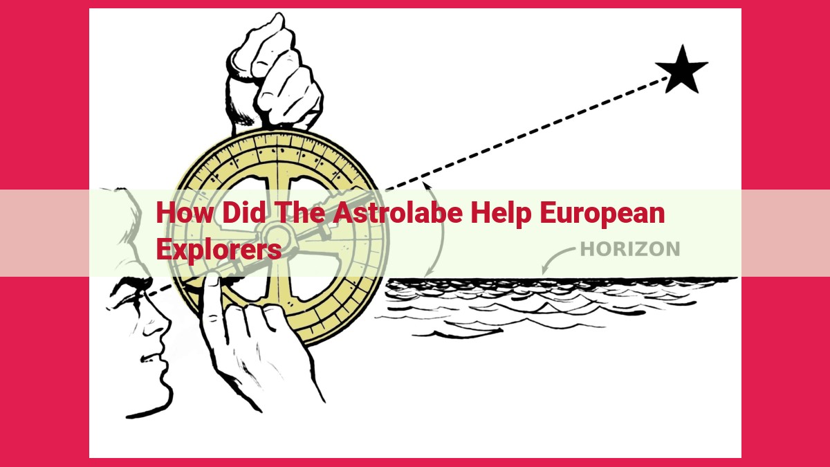
The astrolabe, a sophisticated astronomical instrument, was an indispensable tool for explorers. With intricate scales and a rotating arm, it allowed navigators to measure the angles between the horizon and various celestial bodies, including the Sun and stars. Armed with this knowledge, they could calculate their latitude, a crucial variable for determining their north-south position.
Equally important was the celestial sphere, a spherical representation of the sky. It mapped the stars and constellations, providing a celestial reference frame. By studying the movement of celestial bodies across the sphere, navigators could determine the time of day and monitor changes in their position.
The sextant, a later innovation, further enhanced the precision of celestial navigation. This device utilized mirrors and a graduated scale to measure angles with exceptional accuracy. It enabled explorers to determine the distance between celestial bodies, a vital step in triangulating their position.
Measuring Latitude and Determining the Time of Day: Navigating the Seas with Precision
In the vast expanse of the open seas, where land lay hidden beyond the horizon, European explorers faced the daunting task of charting their course. Among the invaluable tools at their disposal were instruments for determining their latitude and the time of day, essential for accurate navigation.
Latitude and the Celestial Sphere
Latitude, the distance north or south of the equator, was crucial for explorers to know. The astrolabe, a versatile instrument, played a pivotal role in this endeavor. With its graduated arc and rotating alidade, sailors could measure the angle between the horizon and celestial bodies like the sun or stars. By knowing the angle and the declination of the celestial body, they could calculate their latitude with surprising accuracy.
Complementing the Astrolabe: The Sextant
As navigation techniques advanced, the sextant emerged as a more precise tool for measuring angles. This device, with its two mirrors and adjustable arc, allowed for more accurate measurements, particularly when observing the stars. Sailors could use the sextant to determine both latitude and longitude, further enhancing their ability to pinpoint their position on the vast ocean.
Beyond Latitude: Determining the Time of Day
Knowing the time of day was equally important for navigation. Sundials, hourglasses, and clocks served as the primary timekeeping devices of the era. Sundials, harnessing the sun’s position, provided a rough estimate of the time, while hourglasses, with their measured flow of sand, marked intervals of time. As technology progressed, clocks became more sophisticated, allowing for more precise timekeeping essential for determining their longitude.
By combining these ingenious instruments and techniques, European explorers overcame the challenges of measuring latitude and determining the time of day. These navigational advancements laid the foundation for successful voyages, enabling them to chart new territories and connect distant lands, forever transforming the map of the world.
Calculating the Distance to Land: A Navigator’s Quest
In the vast expanse of the open seas, knowing the distance to land was a constant enigma for early explorers. Navigating the uncharted waters demanded innovative ways to gauge their proximity to terra firma.
Limitations of Distance Estimation
Determining the distance from land posed formidable challenges in the pre-modern era. Explorers lacked precise instruments and relied on observations and estimations. Astronomical methods, while useful for celestial navigation, were ineffective for measuring land distances.
Estimating Distances by Sightings
One method involved estimating distances based on the apparent size of landforms. By observing the height of mountains or headlands, navigators could roughly gauge their range. However, these estimates were highly subjective and influenced by atmospheric conditions and the observer’s experience.
Dead Reckoning: Navigating by Distance and Direction
Dead reckoning was another technique used to approximate distance traveled. By continuously measuring the speed of their ship and noting the direction of travel, explorers could calculate their approximate position. However, accumulated errors and the influence of currents could lead to significant inaccuracies over time.
Despite these limitations, these early methods of distance estimation were essential for explorers to chart their course and safely reach their destinations. Their ingenuity and perseverance paved the way for the development of more precise navigation techniques that would revolutionize seafaring forever.
Predicting the Weather: A Crucial Aspect of European Explorations
In the perilous age of exploration, navigating vast oceans posed countless challenges. Among them, understanding and predicting weather patterns was paramount for the survival and success of European explorers. Without precise weather forecasts, early seafarers relied on keen observations and an intimate connection with the natural world to anticipate upcoming weather conditions.
Observing the Sky, Reading the Signs
Early explorers possessed an uncanny ability to interpret the subtle cues of the sky. Sunrises and sunsets, often vibrant displays of color, hinted at approaching storms. The presence or absence of clouds, their formation and movement, provided invaluable clues about wind patterns and precipitation. Explorers also closely observed the moon and stars, noting their position, brightness, and any unusual phenomena.
Connecting with the Environment
Beyond celestial observations, explorers attuned their senses to the changes in their surroundings. Variations in temperature, humidity, and wind direction served as early warning signs of impending weather events. The behavior of birds, sea creatures, and even insects held clues about the approaching conditions. For example, the sudden disappearance of seabirds or the rapid movement of crabs onshore signaled an approaching storm.
Educated Guesses and Wisdom
Armed with these observations, early explorers made educated guesses about upcoming weather patterns. They drew on centuries of accumulated knowledge, passed down through generations of sailors and navigators. This collective wisdom, coupled with their keen observation skills, allowed them to make informed decisions about their course of action.
Importance for Success
Accurate weather prediction was vital for exploration. Favorable winds could propel ships forward, while adverse conditions could lead to disaster. By anticipating upcoming storms, explorers could seek shelter in safe harbors or adjust their course to avoid treacherous waters. Conversely, knowledge of clear weather patterns enabled them to make the most of favorable sailing conditions, maximizing their progress across vast oceans.
In conclusion, weather prediction was a critical aspect of European explorations. Through meticulous observations of the sky and their surroundings, early explorers gained a deep understanding of the natural world, allowing them to make educated guesses about upcoming weather conditions. This knowledge played a crucial role in ensuring their survival, guiding their navigation, and ultimately shaping the course of human history.
Additional Tools and Techniques
Beyond the astrolabe, celestial sphere, and sextant, European explorers relied on an array of other ingenious tools and techniques to guide their intrepid journeys across the vast oceans.
Magnetic Compasses: A Guiding Light Through Uncharted Waters
The magnetic compass emerged as an indispensable tool, providing a constant reference point in the seemingly boundless expanse of the sea. Its needle, magnetized to align with the Earth’s magnetic field, allowed explorers to determine the direction of true north, enabling them to chart their course with greater precision.
Maps: A Roadmap of the Unknown
Maps, meticulously drawn by cartographers and explorers, served as invaluable roadmaps to the unknown. They depicted coastlines, islands, and other geographical landmarks, providing a visual representation of the explorers’ progress and the challenges that lay ahead. By comparing their position on the map to their observations of the stars, they could refine their navigation and avoid perilous obstacles.
Logbooks: A Chronicle of the Voyage
Logbooks, meticulously maintained by the ship’s officers, became a treasure-trove of navigational data. They recorded daily observations of celestial bodies, weather conditions, and the ship’s position, creating a valuable record of the voyage that could be used for future reference and analysis. By comparing their current observations with those from previous logs, explorers could identify patterns and anticipate upcoming weather events or landfalls.